
The pandemic has warped many people's perception of time, but some Americans can be excused for double-checking their calendars this week. It seems like Mother Nature has also lost track of time this year. For scores of people living in states across the Rockies and middle of the country, late October is looking more like late January with record-breaking snowfall blanketing states from Montana to New Mexico.
According to AccuWeather Senior Meteorologist Bill Deger, accumulating snowfall was the result of a powerful storm combining with a deep dip in the jet stream
October snowfall is fairly typical for most of the region, but the magnitude of the storm system that lunged across the West was "certainly impressive," Deger said.
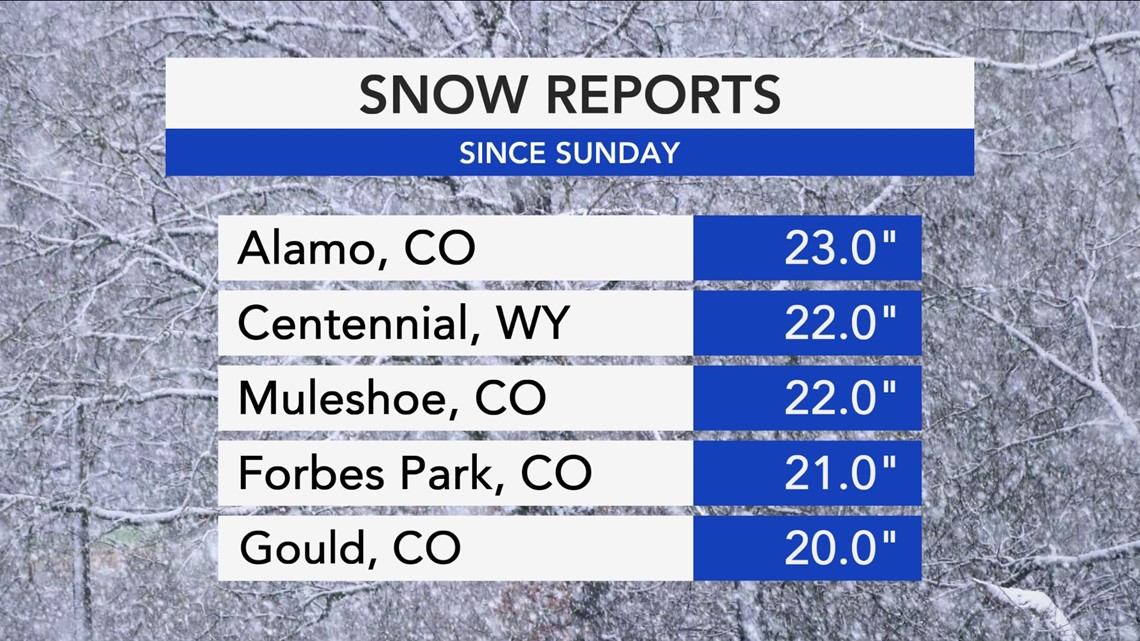
Snowfall totals from the storm ranged from 5 to 25 inches and spanned from Washington down to New Mexico. For some cities, the single storm's snowfall pushed the monthly totals over the edge and led to several broken records.
According to the National Weather Service office in Great Falls, Montana, the city shattered its October snowfall record with nearly 28 inches accumulated over the span of only nine days, compared to the record of 18.5 inches set in 1925.

Precipitation fell so heavily that more than two dozen airports reported thunder along with falling snow and freezing rain in a three-hour timespan early on Monday, according to AccuWeather Senior Weather Editor Jesse Ferrell.
On top of the record-breaking snow, many areas felt teeth-chattering cold with temperatures falling well below previous record thresholds. The lowest reading of the weekend came from Potomac, Montana, which dipped all the way down to minus 29 F on Sunday.
A photo posted on Twitter by the NWS Missoula office showed the 29.2-degree reading on a Nimbus digital thermometer alongside a photo of cattle on a snowy range huddling together looking as though they were attempting to stay warm in that brutally cold air.
The sensational photo was shot by Justin Iverson, a third-generation cattle rancher in Potomac who along with his wife owns Iverson Ranch. Iverson, 43, told AccuWeather in an email, "It's rare to have it this cold in October, but we did hit minus 14" last year on Oct. 29. "The combination of 18 inches of snow followed by brutal cold was unprecedented." But, he said, there wasn't "much wind and this weekend was perfectly calm and sunny." He added, "This would have been unimaginably brutal if we had to deal with wind chill as well."
As for the cows, Iverson said the temperature often plunges to minus 30 in January and February, and the cattle can handle it. "As long as they have plenty of feed and access to clean water they do fine," he said. But the snow that came in before the Arctic air meant the cattle were forced to make some changes to their routine.
"This time of year our cows are usually out grazing the hay meadows, but the snow limited access to the grass so we've been feeding alfalfa hay for the last few days and hope to thaw out and get back to grazing," Iverson said.
There was a slew of breathtaking low temperatures recorded around the state.
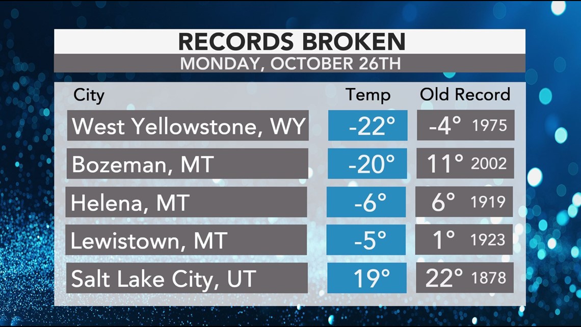
Also in Montana, a record-low temperature of 5 F was recorded in Billings on Sunday, breaking the previous daily record of 18 F from 1997 in the city. The mercury in Glasgow, Montana, plummeted to minus 2 F on Monday morning, shattering the old daily record low of 2 F set in 1919. West Yellowstone also plunged to minus 22 F on Monday morning, obliterating the old daily record low of minus 4 F from 1997.
"It's not normal to set this many records in this short of a time - and monumental records," Corby Dickerson, a meteorologist in the NWS Missoula office told AccuWeather. Dickerson has been working as a meteorologist at the NWS for 15 years and described the historic cold snap as "a once-in-a-lifetime opportunity" for a forecaster given how early this type of extreme cold swept in.
Perhaps, as the NWS Great Falls put it, the "winner" was Bozeman, Montana, which saw the biggest departure from its daily record. Bozeman, which The Washington Post reported has seen an influx of people relocating there from big cities during the pandemic, reached a low of minus 20 F, some 31 degrees below its previous record low of 11.

Through Wednesday morning, 1 to 3 inches of snow are possible in areas from northern New Mexico to Iowa. In areas of higher elevation in central Colorado and Nebraska, those totals could even climb to 12 inches.
Wichita, Kansas, recorded a daily record snowfall of 1.3 inches on Monday, beating out the old daily record of 0.5 of an inch set all the way back in 1913. The accumulation of snow was also the most snow the city has ever picked up this early in the season, according to the National Weather Service.
Farther south, falling temperatures could present a significant, long-lasting ice potential across the southern Plains.
"As temperatures plummet from the southern Texas Panhandle into southeastern Missouri, there is potential for up to half an inch of ice accumulation with freezing rain and sleet [through Wednesday morning]," AccuWeather Meteorologist Maxwell Gawryla said. "Even a thin coating of ice can cause major disruptions and pose a dangerous threat to any travel."
By early Monday afternoon, up to a quarter of an inch of ice had accumulated in Estelline, Texas, a tiny town located in the eastern part of the state's panhandle, with 0.2 of an inch in Yukon and Chautauqua, Oklahoma, both located in central parts of the state.
The ice in Oklahoma led to nearly 130,000 people affected by power outages on Monday evening, according to PowerOutage.us.
For those residents accustomed to typically warm autumn conditions in the southern Plains, temperatures should return to normal by the end of the week.
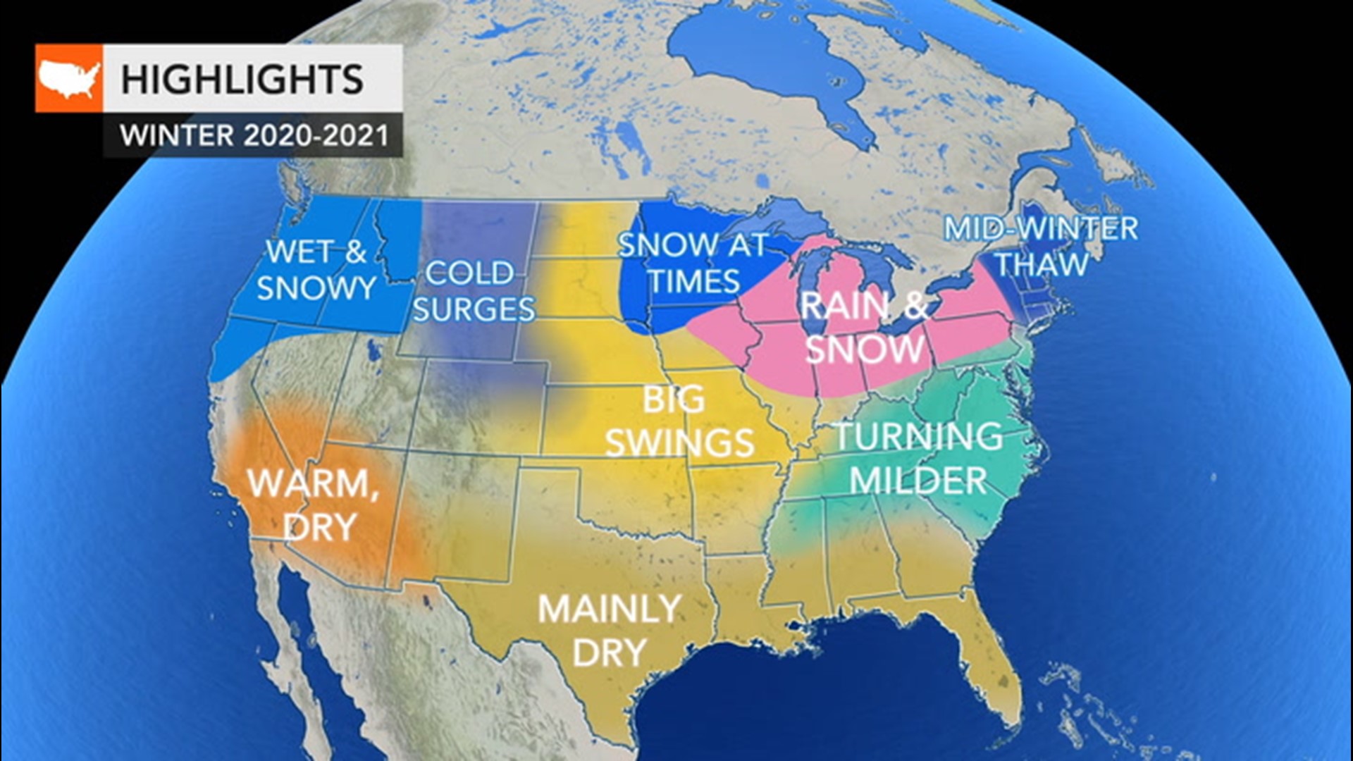
"Fortunately, following this big storm and cold blast, and the several smaller ones that preceded it last week, it appears the pattern will change to a drier, gradually warmer one across much of the Rockies and Plains as we head through the middle and end of this week," Deger said.