COLUMBIA, S.C. —
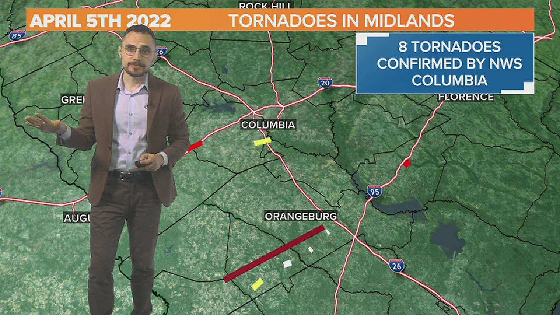
The National Weather Service in Columbia has completed their tornado surveys from the April 5th 2022 tornado outbreak and determined there were 8 tornado touchdowns in the South Carolina Midlands including an EF3 in Bamberg and Orangeburg county, a EF-2 in Lexington County, and a second EF-2 in Clarendon county. In total, there was only one injury and no fatalities from the tornadoes in the Midlands. You can read the full survey report on the NWS Columbia website. Below we have a brief summary.
Note: this write up and the graphic below does not include the EF-3 Allendale tornado that occurred after 3 PM and had maximum sustained winds of 137 mph. You can read information about that tornado and others in the low country in the National Weather Service Charleston writeup.

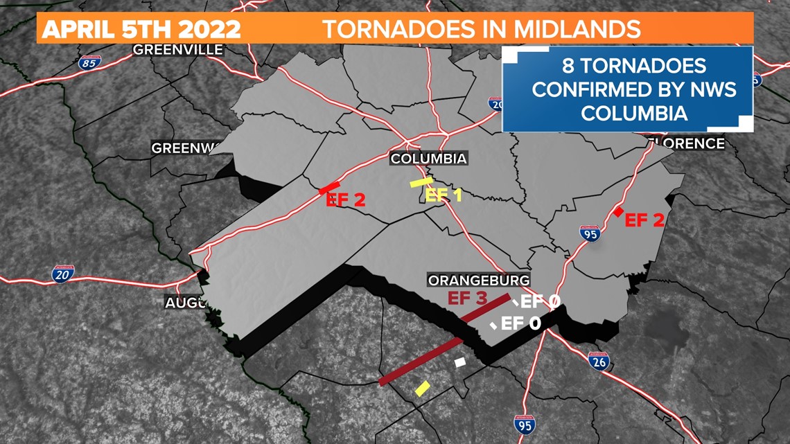
EF0 Tornado in Orangeburg County near Branchville
This EF-0 tornado had estimated peak winds of 80 mph and was on the ground for about 1 mile. The tornado touched down just east of Branchville in Orangeburg County at 4:53 PM and dissipated at 4:55 PM a mile to the northeast.
According to the National Weather Service, the tornado touched down in the athletic fields adjacent to Branchville High School on Dorange Rd. They determined the metal roof was removed from an equipment shed, the baseball field backstop was missing a portion of its fencing, and the bleachers were displaced. The tornado continued northeast across a field, removing sections of roof near the intersection of Thompson Rd and Sub Rd, before dissipating.
EF0 Tornado in Orangeburg County near Bowman
This EF-0 tornado had estimated peak winds of 85 mph and was on the ground for about 3/4 mile. The tornado touched down just southwest of Bowman in Orangeburg County at 5:07 PM and 2 minutes later.
The National Weather Service storm survey determined the tornado touched down near Wayside Dr where it removed portions of the tin exterior of a farm equipment storage barn and shifted an unanchored helicopter more than 90 degrees. The report goes on to say the tornado moved northeast across Dairy Ave where it caused damage to approximately 6 acres of a solar farm.
EF-2 Tornado in N Aiken / S Lexington County

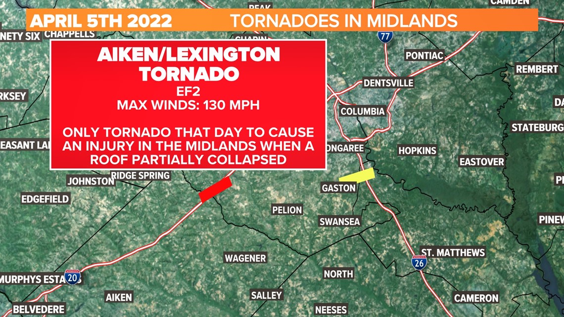
The National Weather Service storm survey confirmed and EF2 tornado from northern Aiken County into southern Lexington County. The tornado touched down at 5:35 pm and was on the ground for 12 minutes, dissipating just under 6 miles to the northeast with a maximum path width of 100 yards. Peak winds were estimated at 130 mph.
The National Weather Service found the tornado damage began near the intersection of Holder Road and Huckleberry Finn Road. The tornado eventually crossed I-20 just west of
mile marker 39, near exit 39 and later crossed Highway 178. (Fairview Highway) as it continued northeast toward Live Oak Road and Annie Hallman Road.
Downed branches, uprooted trees and snapped trees were found in the tornado's path. The NWS found the most significant damage occurred along Holder Road and Fishhook Lane. The following is directly from their report:
"The tornado damaged 3 homes and downed power lines in the area. A small wooden home lost a portion of it's metal roof. A home was partially pushed off its foundation. Some of
the supporting piers collapsed and the home had signs of buckling along the side and rear walls. This home is were the one injury occurred, as the roof partially collapsed. The third home was damaged when a tree fell on the roof. There were numerous downed, uprooted and snapped trees around the 3 homes. The area was initially inaccessible until county clean up crews arrived. The tornado continued northeast along Fishhook Lane where significant tree damage occurred. There were numerous large hardwood and softwood trees that were snapped at the end of Fishhook Lane. A small metal shed was destroyed. A rusted antique car was moved approximately 50 feet where it had resided in the shed. A car engine was moved approximately 35 feet from where it resided in the shed. The home on the property had a couple of small areas of damage where the wooden siding was removed."
The tornado finally dissipated just beyond the intersection of Annie Hallman Road and Live Oak Road.
EF-3 Bamberg/Orangeburg County Tornado

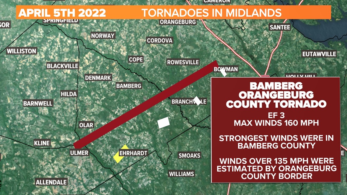
This was the strongest tornado of the afternoon in the Midlands. Maximum sustained winds were estimated at 160 mph with winds as high as 135 mph when the tornado crossed into Orangeburg county as it weakened.
The National Weather Service in both Columbia and Charleston worked together to determine the damage from this strong EF3 tornado that started in Allendale and moved into Orangeburg County. The tornado was on the ground for nearly 36 miles starting at 6:03 pm near Ulmer and lasting until 6:53 pm where it dissipated near Bowman. The following is directly from the NWS survey report:
"The initial touchdown point was along Wells Branch Road near the Barnwell County line in Allendale County and crossed into Bamberg county near the intersection of Highway 321 and Highway 301. After this point, the tornado rapidly intensified and moved through a large forest of mostly softwood pine, with hardwood oaks in the forest for some stretch. As it approached Popeye Rd in Bamberg County, the tornado strengthened into a strong EF3 with winds estimated at 160 mph. Remarkable damage was done to both softwoods and hardwoods in this forest, with an estimated 2 miles of 80-100% forest blowdown. In a particularly intense section, the tornado scoured the ground and stripped pine needles off of young pine trees. Additionally, many younger pine trees in this area were debarked and delimbed. On either side of this were sections of pine and oak that had been snapped low, at or below 5 feet, to the ground. Strong EF3 damage is estimated to have continued from Popeye Road across Kirkland Creek and then towards Wild Flower Road in Bamberg County. From here, the tornado weakened a bit as it approached Alligator road. The tornado was near its peak width at this time, then striking a more residential area along Carver road. Here, one mobile home was completely destroyed, with a home having its roof completely gone and some partial wall collapses. On either side of the center of the track, other homes sustained different degrees of damage to their roofs and siding.
The tornado continued northeastward and maintained some EF2 strength as it did so, primarily to trees. Much of the damage on Macedonia Church Rd was from trees falling on homes. The tornado showed signs of weakening by this point as it approached Orangeburg county, and it is distinctly possible that there were multiple weak vortexes impacting only the tops of trees. EF0
and weak EF1 damage was noted until the county line with Orangeburg, where the tornado regained some of its strength and continued doing damage. The tornado approached the North Fork of the Edisto river and impacted a couple of homes, doing some significant tree damage on both properties. As the tornado approached Freedom Road in Orangeburg County, it produced EF0 and EF1 damage continuing to snap trees. The tornado continued to weaken gradually as it approached the city of Bowman, finally dissipating about 2 miles north of the city around 6:53 PM.
EF-1 Gaston Tornado

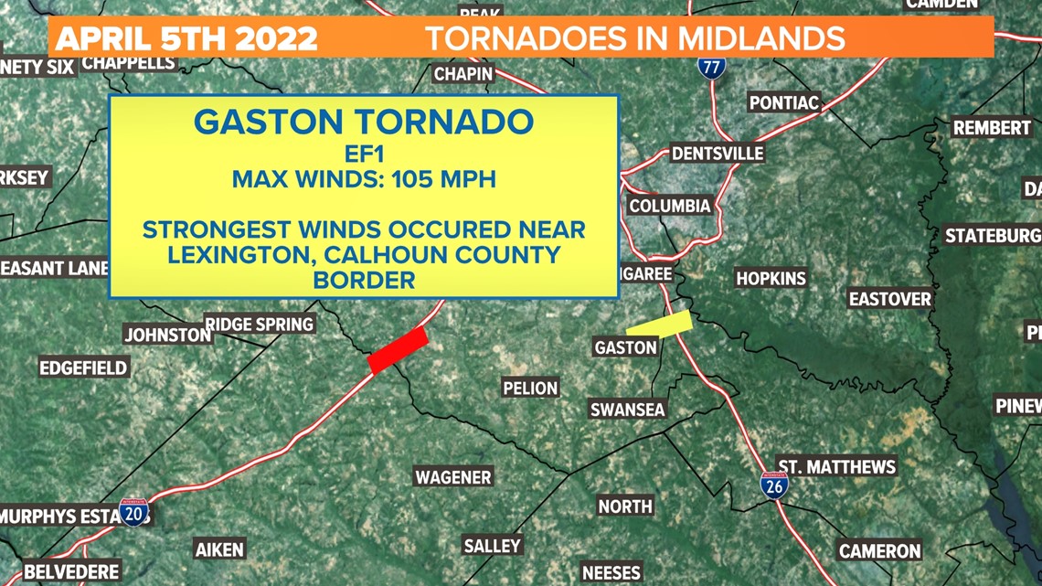
This tornado was determined to have 105 mph maximum strength winds. It was on the ground for just under 6 miles and approximately 9 minutes starting at 6:20 PM.
The report from the National Weather Service finds the tornado touched down along Highway 321 near just north of the town of Gaston. The most significant damage began near the Lexington County and Calhoun County line along Dixon Road and Savany Hunt Creek Road.
The tornado crossed I-26 near mile marker 22 and brought down numerous limbs and trees between the county line and I-26.
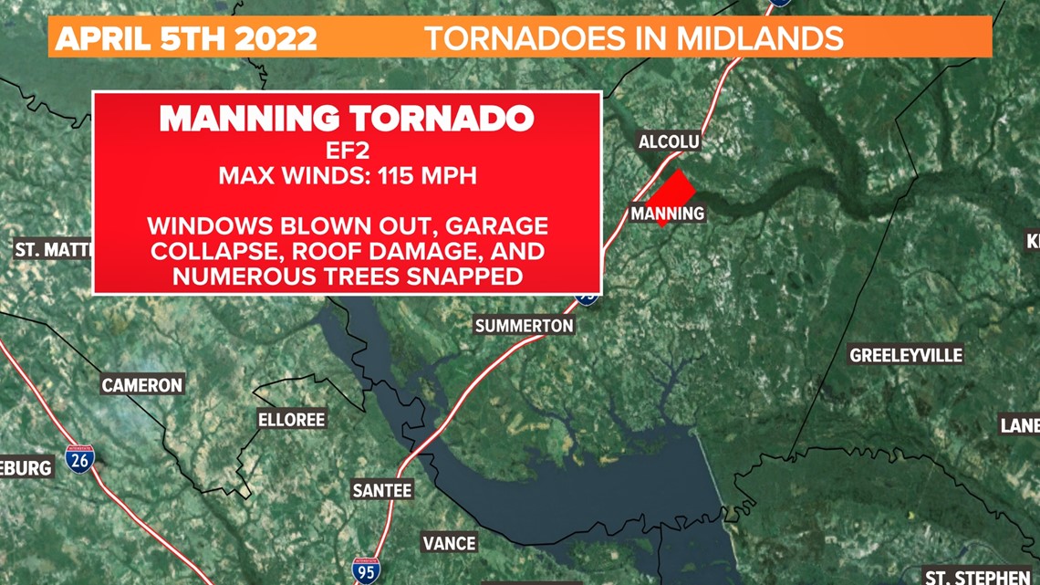
Final Tornado of the evening, an EF-2 in Manning
The final tornado of the night touched down in Clarendon county at 7:38 pm and was on the ground for just under 5 minutes. The tornado came more than 1 hour after Gaston tornado lifted and had peak winds of 115 mph. The path was 3 miles long. Along the way, there were reports of a flipped pickup truck in the Walmart parking lot and damage to two rooftop HVAC units 15 feet from the Walmart. The tornado blew out the windows on one side of a home and caused minor roof damage to several other homes in the area. The room above a garage was completely broken down after the roof failed.