
NEW ORLEANS — A tornado that seemed to form on the west bank of Jefferson Parish and travel through parts of New Orleans and into the Arabi area of St. Bernard Parish is responsible for at least one death, multiple injuries and several damaged and destroyed buildings.
WWL-TV Chief Meteorologist Chris Franklin said the pattern of the damage and the extent of it would likely mean the tornado was an Ef-2 or EF-3.
The tornado was first reported shortly after 7 p.m. when the worst of the severe weather was expected to be wrapping up with little fanfare. That quickly changed. There were multiple tornado warnings that overlapped, power went out in the hard hit areas, including WWL-TV's studios, which caused the station to rely on generator power during its coverage.
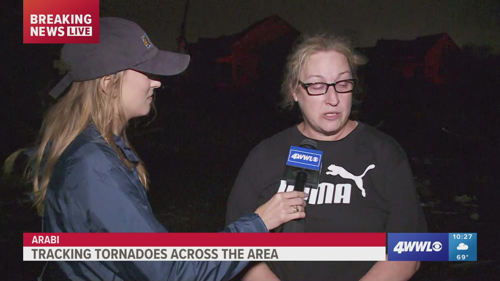
St. Bernard Parish President Guy McInnis said that the person who died was in Arabi. Several videos from viewers showed the large tornado ripping through Arabi and videos in the aftermath showed severe damage that included leveled homes, overturned cars and fields of debris.
"We have widespread damage from south Arabi to north Arabi," he told Eyewitness News. "We’re going through homes, search and rescue and clearing homes. We have some homes in south Arabi that we’re trying to get to, we’re getting calls from people saying they’re trapped."
The damage wasn't as extensive in New Orleans East, the Lower Ninth Ward and the west bank of Jefferson Parish, but people who lived in those areas did have fences down and some home damage and people readily admitted they were scared.
Entergy's power outage map showed 14,000 customers without power in parts of Orleans, St. Bernard and Jefferson Parishes, especially in the hard hit areas. That number had dropped to about 7,500 as of 10 p.m.
A man whose family hunkered down in Arabi and whose home had damage, described the situation as the storm came through.
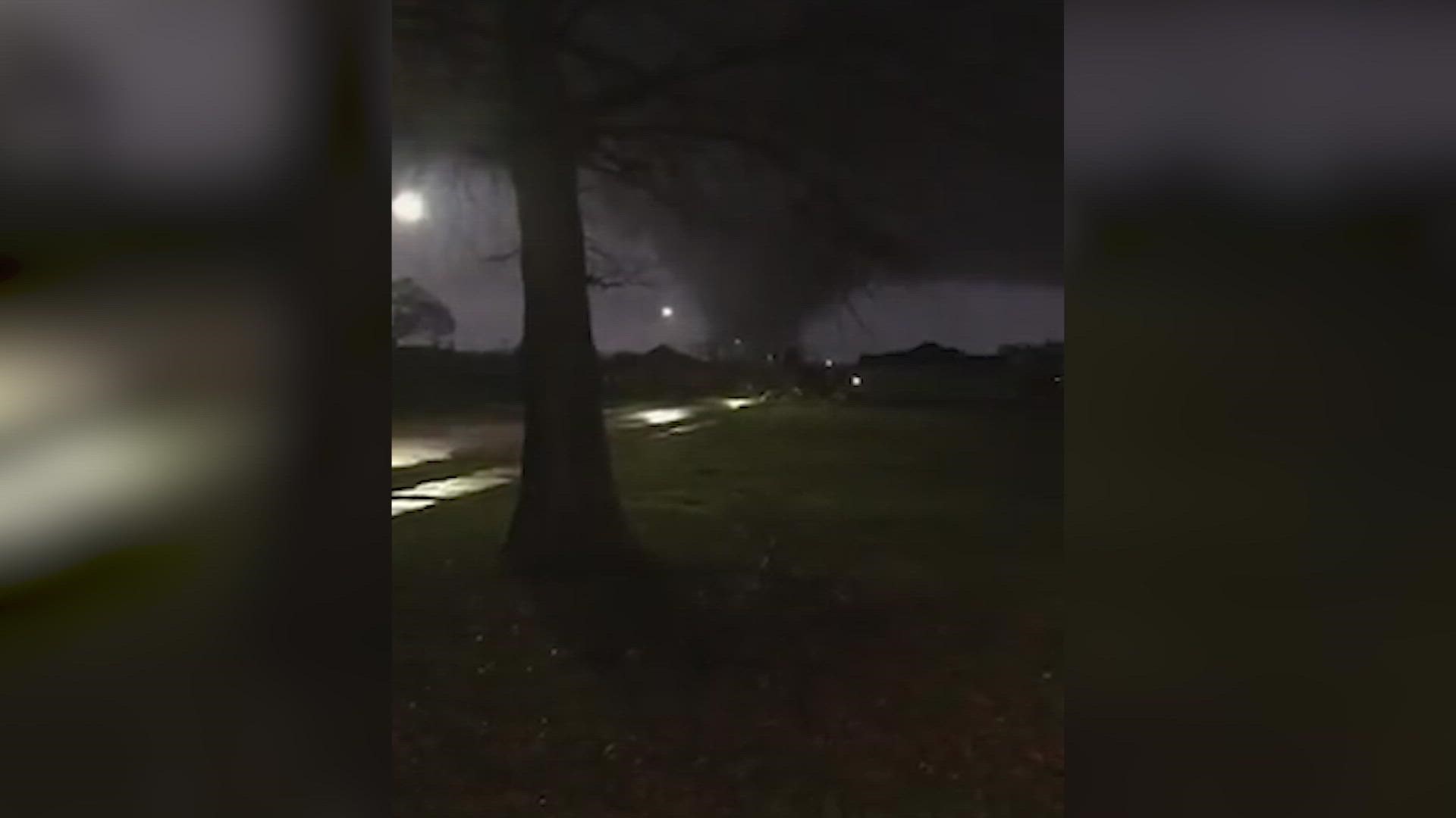
Viewer video tornado in Arabi: Mike Roberts
"It was just the rain and we didn't hear anything change like a freight train and it just all of a sudden happened," he said. "My wife, my sister-in-law, my 10-month-old son and two dogs were all in one bathroom."
He said his neighbor's home was moved off of its foundation.
The tornado was over parts of the west bank of Jefferson Parish prior to striking Arabi and New Orleans.
In Gretna and Terrytown, Councilman Ricky Templet said damage was limited to mostly downed fences and some trees.
A man who rode out the storm, told WWL-TV that the "sky turned green" as the tornado was hitting.
New Orleans Director of Emergency Preparedness, Colin Arnold, said damage in the city seemed to be limited to the Lower Ninth Ward. He said they weren't aware of the extent of the damage there, but he didn't believe there were bad injuries.
Orleans Councilman Oliver Thomas said that he had been surveying the damage in the Lower Ninth Ward and that it didn't appear to be much damage, but, "it's so dark."
New Orleans Mayor LaToya Cantrell said that there are no reports of deaths in Orleans Parish as of Tuesday night. She also said that resources are being sent to St. Bernard Parish to help with their rescue and recovery efforts.
"I am also in contact with St. Bernard Parish President Guy McInnis, and the New Orleans Police, Fire and EMS Departments have begun staging in St. Bernard Parish to assist our neighbors with help in any way possible," Cantrell said.
In addition, multiple reports of tornado sightings have come from southeast Louisiana, including in Terrytown and in part of St. Tammany.
Power was knocked out at WWL-TV studios and the station is operating on generator power.
VIDEO: FROM Kari Klotzbach
With the upper disturbance moving east, the main energy will depart the region, taking the severe threat and the line of storms away from the area. Clearing skies, falling humidity and temperatures overnight. Lows to begin the day Wednesday in the 50! Lots of sunshine through the rest of the week with highs in the upper 60s Wednesday then low 70s through the week and into the start of the weekend. Surface high pressure will begin to shift to the east on Sunday, allowing winds to return to a SE direction, increasing humidity and temperatures and low 80s return early next week.
Detailed Forecast:
TONIGHT:
Storms moving east. Clearing skies. Cool, breezy. Low: S 53, N 51. Winds: W 10-18.
WEDNESDAY:
Mostly sunny skies. Cool & breezy. Very pleasant! High: 68. Winds: W/NW 8-15.
THURSDAY:
Cool AM. Sunny and mild. Low: S 49, N 44. High: 72.
FRIDAY:
Cool AM. Sunny and mild. Low: S 50, N 45. High: 72.
SATURDAY:
Cool AM. Sunny and mild. Low: S 52, N 45. High: 73.
SUNDAY:
Mostly sunny. Little warmer, wee bit more humid. Low: S 54, N 47. High: 76.
MONDAY:
Partly cloudy. Warmer, more humid. Breezy. Low: S 60, N 54. High: 81.
TUESDAY:
Partly cloudy. Warm, more humid. Breezy. Low: S 64, N 60. High: 81.
► Stay in the know with Southeast Louisiana's top stories to start your workday. Sign up for the 4 Things to Know email newsletter to get headlines delivered to your inbox. Click here to sign up!
► Get breaking news from your neighborhood delivered directly to you by downloading the new FREE WWL-TV News app now in the IOS App Store or Google Play.