
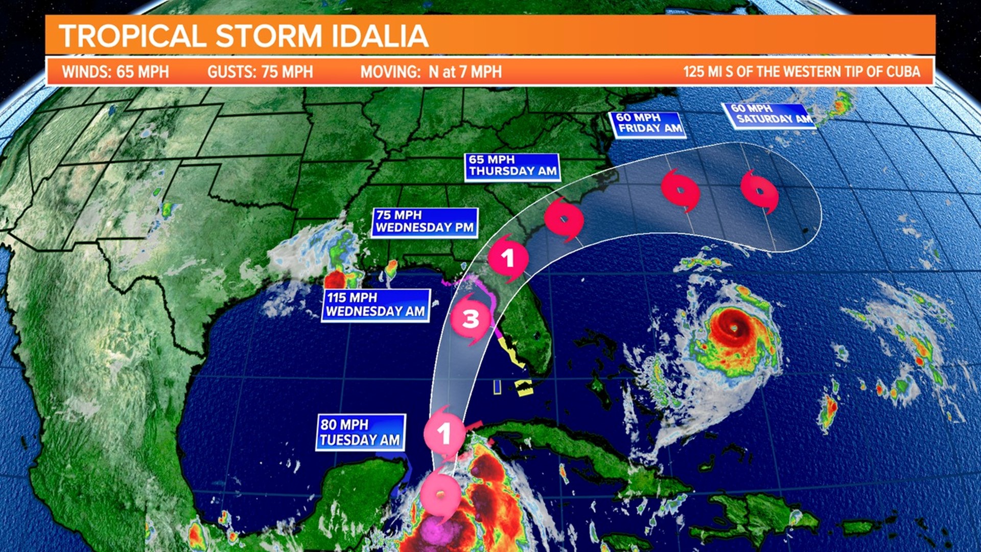
COLUMBIA, S.C. — Tropical Storm Idalia has intensified. It is forecast to become a hurricane later today. Interests along the southeastern U.S. coast should keep an eye on the system's progress. More watches and warnings are likely later today.
Idalia is expected to become a major hurricane before reaching Florida's Gulf Coast. Beginning as early as late Tuesday, the risk of life-threatening storm surge and dangerous hurricane-force winds along portions of Florida's west coast and the Florida Panhandle has increased.
Storm surge and hurricane watches are in effect for parts of Florida's west coast and the Florida Panhandle, and residents in these areas should keep an eye on forecast updates and heed any local officials' advice.
Flash and urban flooding, some of which may be locally significant, are expected along parts of Florida's west coast, the Florida Panhandle, and southern Georgia. Tuesday into Wednesday and Thursday, spreading into parts of the eastern Carolinas.


Later today, hurricane-force winds are expected across portions of far western Cuba. Heavy rain is also expected across parts of western Cuba, potentially causing flash flooding and urban flooding as well as landslides.
South Carolina Impact:
Idalia is expected to make landfall near Florida's big bend late Tuesday night or early Wednesday morning, then track northeast through Georgia and near the coast of South Carolina. Uncertainty remains on the track of Idalia because it is still a few days away from affecting our area, leading to some uncertainty in associated hazards.

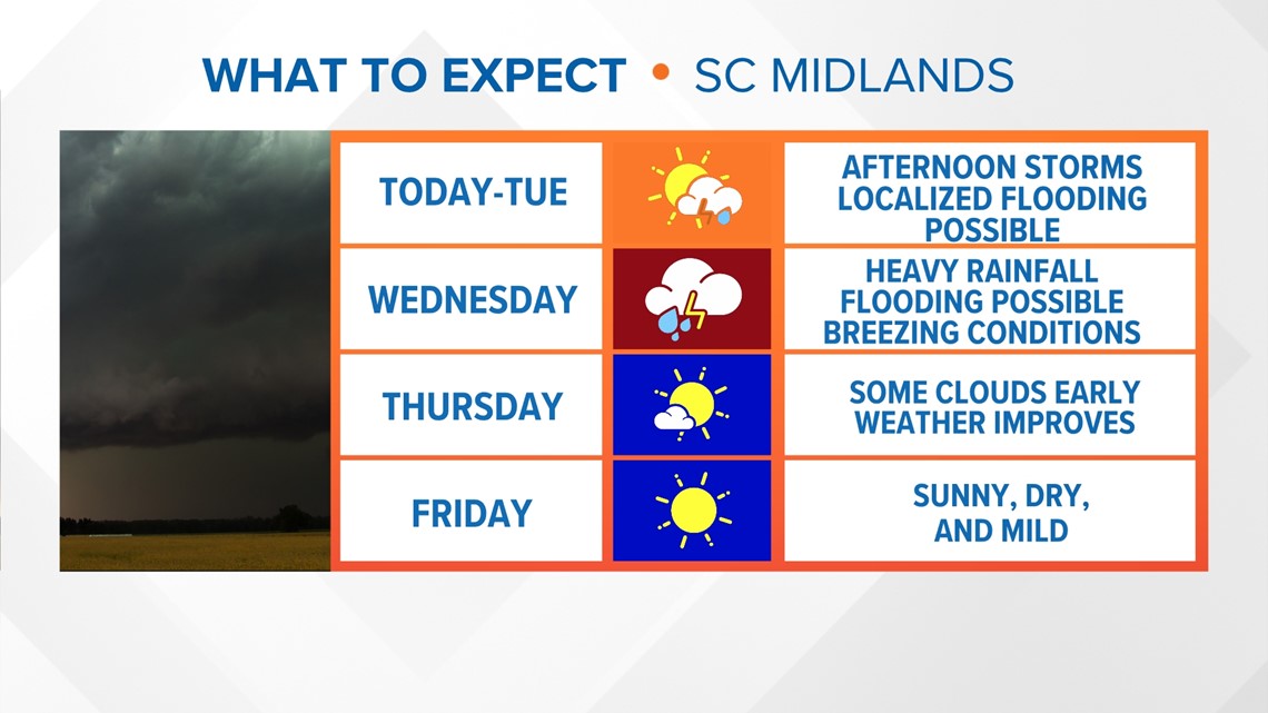
Given the conditions of recent rainfall, the primary hazard remains the potential for heavy rain and the associated flooding risk. Other hazards are highly dependent on Idalia's path. Idalia is currently expected to affect the forecast area Wednesday evening into possibly early Thursday morning.
Rainfall amounts of 4-6" are possible for the eastern Midlands, with locally higher amounts and lower amounts elsewhere. The location of the heaviest rainfall is also track dependent.

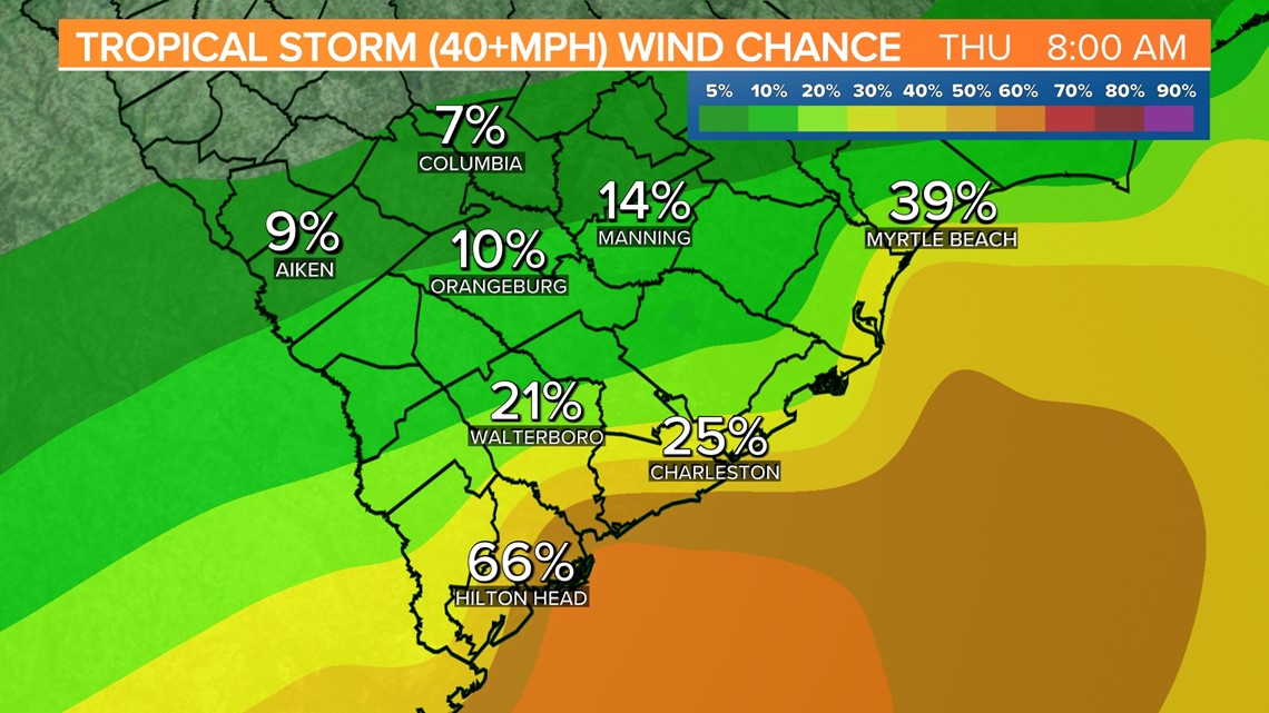
The Weather Prediction Center has parts of the state at moderate risk of excessive rainfall. This is mainly along and east of I-95. According to the Storm Prediction Center, that is the same general area that is under a minor threat of severe weather.
The coastal region is most vulnerable to tropical storm force winds. The likelihood of strong winds decreases as you travel north and west across the state.


Small changes in the track and intensity could lead to big changes in the local impacts. Stay tuned to the weather the next few days as we continue to track Idalia.