

COLUMBIA, S.C. — A cold front will move through the area tonight, bringing scattered strong thunderstorms. Despite the storms, temperatures will stay above normal. Expect more seasonable and drier weather beginning by mid-week as high pressure builds in.
Today's weather will be impacted by a mesoscale convective system (MCS) passing through, impacting our area into the early afternoon. Another round of storms is expected as the cold front approaches from the west. The timing of the MCS is uncertain, but it could arrive and dissipate earlier than forecasted, leading to increased atmospheric instability this afternoon.
High-resolution models predict scattered thunderstorms, particularly in the Central Savannah River Area (CSRA), by early afternoon. These storms may develop along outflow boundaries and differential heating zones left by the morning's decaying MCS. Moisture levels will be high, which could lead to isolated flooding if storms train over the same areas.

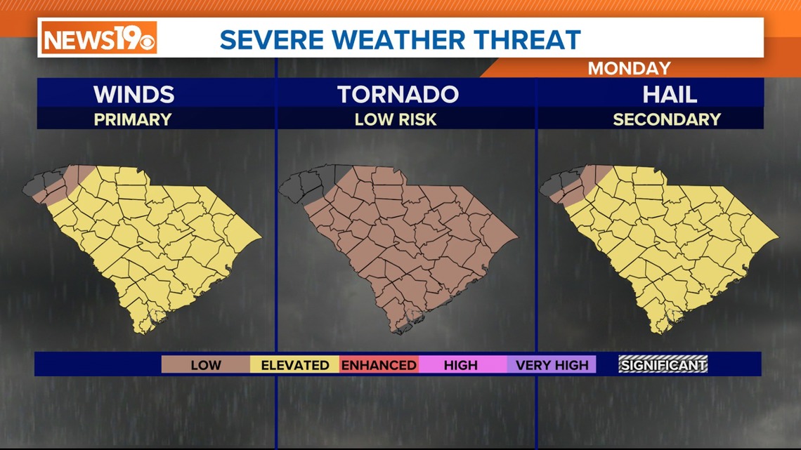
The Storm Prediction Center (SPC) has placed South Carolina at a slight risk for severe weather today, with damaging wind gusts as the main threat. Thunderstorms should move eastward and weaken by around 9 p.m. as the cold front pushes through the region.
Today's highs will range from the mid-80s in the western Midlands to the lower 90s in the eastern Midlands. Overnight lows will drop to the mid-60s west and around 70 east as cooler, drier air moves in.
Behind the cold front, drier air will settle in on Tuesday and Tuesday night, with zonal flow aloft and slight height rises. The upper-level trough to the north will remain stationary, but without significant forcing, conditions should stay dry. Highs on Tuesday will reach the upper 80s to low 90s, with clear skies. Overnight lows will be more seasonable, in the low to mid-60s.
Wednesday will see little change in weather, with further drying as precipitable water values drop. Highs will be slightly cooler, in the mid to upper 80s, with nighttime lows in the low 60s.
An upper trough will linger to the north through late this week, bringing occasional disturbances. The American model predicts a shortwave moving through the southern stream on Thursday, potentially bringing showers to the CSRA, while the European model keeps the area dry.

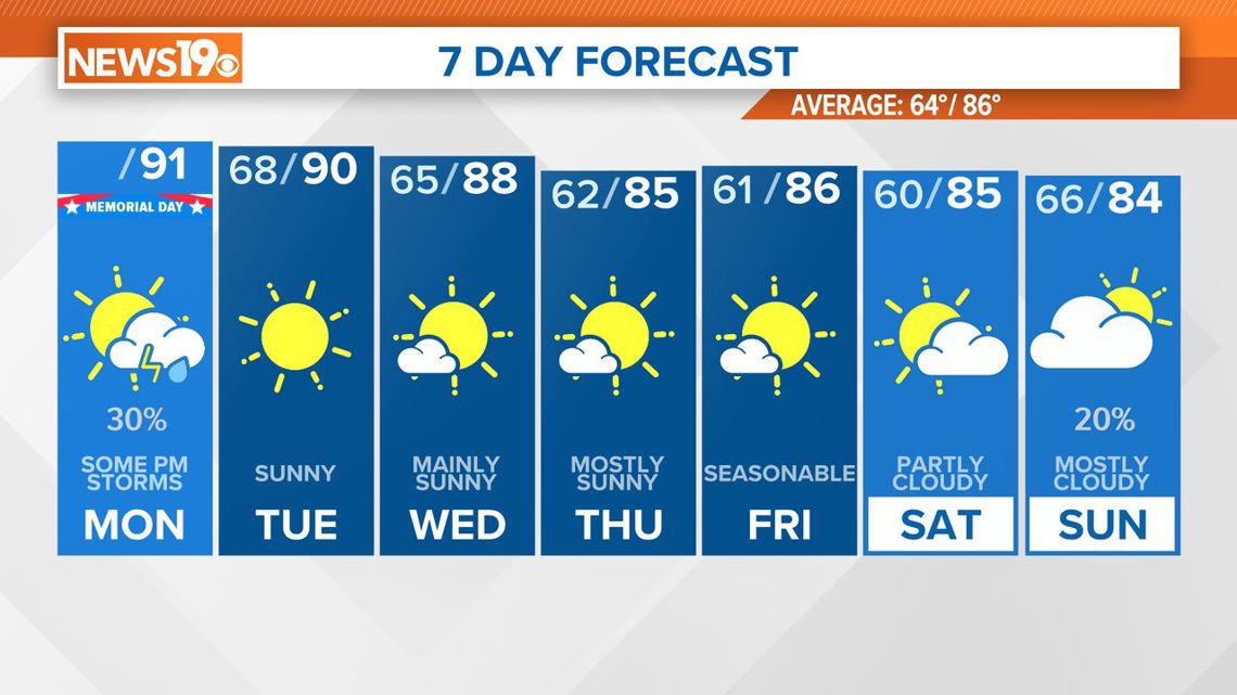
A weak, dry front is expected to move through on Friday, followed by high pressure building in from the west, replacing the trough by the weekend.
By Sunday, onshore flow may increase moisture. Given uncertainties, forecast models suggest dry conditions through Saturday, with a slight chance of showers or storms on Sunday.
Dewpoints will remain in the 50s during this period, with highs in the low to mid-80s Thursday and Friday, slightly below normal for late May. The weekend will see a bit more warming, with highs in the mid to upper 80s and lows in the upper 50s to low 60s.