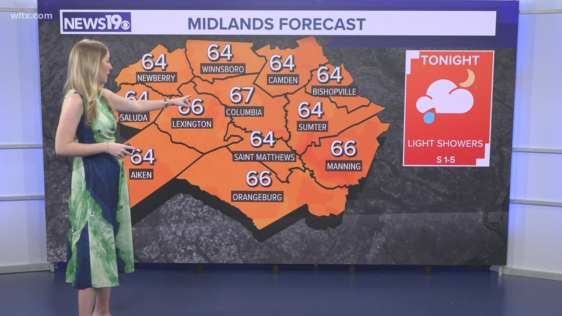
COLUMBIA, S.C. — News19 is tracking a line of strong storms moving through the Midlands of South Carolina. The Storm Prediction Center has issued an enhanced risk for severe weather for the western Midlands.
This potentially severe weather will be moving into the region in the afternoon hours with several parts of the area already under a severe thunderstorm watch well into the evening.
Here's a live look at storms and their impacts as they move through this part of South Carolina.
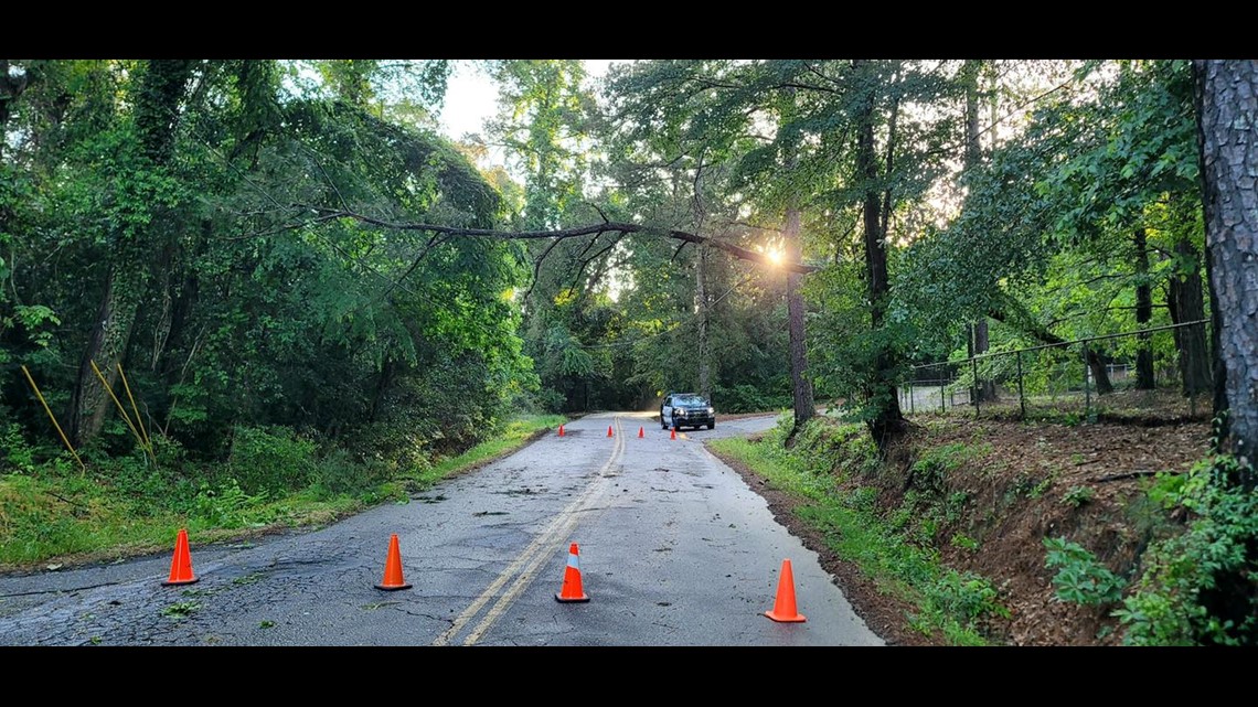
7:35pm | Trees and power lines down in Lexington on Corley street down from the park to Efird Street.

6:33 p.m. | Weather Watcher Alex Thomas reports hail in Rock Hill.
6:30 p.m. | A Severe Thunderstorm Warning has been issued for Kershaw County until 7 p.m.
6:26 p.m. | The Severe Thunderstorm Warning for Clarendon, Lee, Orangeburg and Sumter counties has expired.
6:24 p.m. | The Severe Thunderstorm Warning for Fairfield, Kershaw, and Newberry counties has expired.
6:24 p.m. | The Severe Thunderstorm Warning for Orangeburg County has expired.
6:22 p.m. | The Severe Thunderstorm Warning for Lee County has expired.
6:19 p.m. | The Severe Thunderstorm Warning for Lexington and Richland counties has been canceled but continues for Fairfield, Kershaw, and Newberry counties until 6:30 p.m.
6:17 p.m. | The Severe Thunderstorm Watch for Saluda County has been canceled.
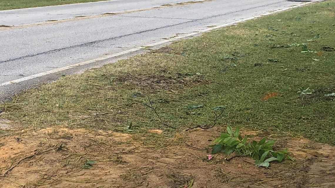
6:15 p.m. | Weather Watcher Michael Smith is reporting some minor damage in Orangeburg County.

6:14 p.m. | A Severe Thunderstorm Warning has been canceled for Calhoun and Richland counties but continues for Clarendon, Lee, Orangeburg, and Sumter counties until 6:30 p.m.
6:13 p.m. | The National Weather Service has issued a Severe Thunderstorm Warning for Fairfield, Kershaw, and Newberry counties until 6:45 p.m.
6:08 p.m. | A Severe Thunderstorm Warning has been canceled for Kershaw County but continues for Lee until 6:30 p.m.
6:07 p.m. | Reports of a developing wall cloud over Lugoff
6:06 p.m. | A Severe Thunderstorm Warning has been issued for Orangeburg County until 6:30 p.m.
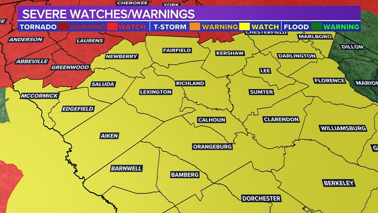
5:59 p.m. | A Severe Thunderstorm Warning has been issued for Fairfield, Kershaw, Lexington, Newberry, and Richland counties until 6:30 p.m. The storm is capable of 70 mph winds and hail of up to 1.25 inches.
5:58 p.m. | A Severe Thunderstorm Warning has been issued for Kershaw County until 6:30 p.m. It's capable of 60 mph wind and hail of up to 1.5 inches.
5:56 p.m. | Columbia Metropolitan Airport reports thunderstorm wind gusts of 44 mph.
5:56 p.m. | A Severe Thunderstorm Warning has been issued for Calhoun, Clarendon, Lee, Orangeburg, Richland, and Sumter counties until 6:30 p.m. The storm is capable of 60 mph winds and hail of up to 1 inch.
5:54 p.m. | A Severe Thunderstorm Warning has been issued for Kershaw and Lee counties until 6:30 p.m. the storm is capable of hail of up to an inch and wind of 60 mph.
5:51 p.m. | The National Weather Service has continued the Severe Thunderstorm Warning for Fairfield, Lexington, Newberry, Richland, and Saluda counties until 6 p.m.
5:48 p.m. | The National Weather Service has continued the Severe Thunderstorm Warning for Fairfield, Kershaw, and Richland counties until 6 p.m.
5:43 p.m. | The National Weather Service has expired the Severe Thunderstorm Warning for Lexington and Saluda counties.
5:43 p.m. | The National Weather Service is continuing the Severe Thunderstorm Warning for Calhoun, Clarendon, Lexington, Orangeburg, Richland, and Sumter counties until 6 p.m.
5:42 p.m. | The Severe Thunderstorm Warning for Sumter has been canceled but continues for Kershaw and Lee until 6 p.m.
5:37 p.m. | The National Weather Service has issued a Severe Thunderstorm Warning for Fairfield, Lexington, Newberry, Richland, and Saluda counties until 6 p.m. The storm is capable of 70 mph winds and 1.25-inch hail.
5:34 p.m. | National Weather Service updates the Severe Thunderstorm Warning for Lexington and Saluda counties until 5:45 p.m. The storm is capable of considerable damage, 70 mph winds, and 1.25-inch hail.
5:33 p.m. | Authorities in Orangeburg County are reporting wind gusts of up to 50 mph at the Orangeburg Municipal Airport.
5:32 p.m. | A trained spotter reports quarter-size hail near Ridgeway in Fairfield County.
5:32 p.m. | The National Weather Service has issued a Severe Thunderstorm Warning for Fairfield, Kershaw, and Richland counties until 6 p.m. The storm is capable of 60 mph wind and 1.5-inch hail.
5:26 p.m. | A Severe Thunderstorm Warning has been issued for Kershaw, Lee, and Sumter counties until 6 p.m.
5:25 p.m. | A Severe Thunderstorm Warning has been issued for Calhoun, Clarendon, Lexington, Orangeburg Richland, and Sumter counties until 6 p.m. The storm is capable of considerable damage, 70 mph winds, and hail of up to 1.25 inches.
5:22 p.m. | The National Weather Service has issued a special weather statement for the Midlands until 5:45 p.m.
5:10 p.m. | A Severe Thunderstorm Warning has been issued for Lexington County until 5:45 p.m. The storm is capable of considerable damage, 70 mph winds, and hail of up to 1.25 inches.
3:48 p.m. | Several South Carolina Counties, encompassing all of the Midlands, have been placed under a Severe Thunderstorm Watch until 10 p.m. This includes Calhoun, Lee, Newberry, Saluda, Fairfield, Lexington, Orangeburg, Sumter, Clarendon, Kershaw, and Richland counties.